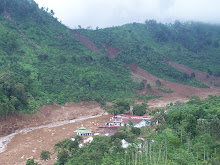
The volcano erupts after rumbling for several days. On August 29, 2010, the increasing activity manifest by white smoke and fumarola solfatara in the active crater. On the following day, Sunday at 00:08 pm, roaring sound heard from the summit area, remarking the main eruption stage. Center for Volcanology and Geological Hazard Mitigation (PVMBG) immediately raised the level alert into its highest level. This volcano previously classified as type B volcano, and after the eruption, PVMBG raised its type into type A.
The 2,460-meter Sinabung volcano located in District Tanah Karo, North Sumatra. The nearest major city is Medan. There is no flight disruption reported yet. The eruption was unpredictable, caused by lack of knowledge in terms of its eruptive patterns and general forms; the last activity recorded in this volcano was that in 1600.
 A villager covers her nose and mouth from volcanic ash as Mount Sinabung spews smoke in the background in Karo, North Sumatera, Indonesia, Saturday, Aug. 28, 2010. (Image source: Associated Press)
Update: Second, more forceful eruption occurred early on Monday, August 30, 2010, forcing more than 20.000 people to remain in evacuation centers. The eruption occurred at 6.30 am create a column of smoke up to 2000 meter into the sky.

Update: Third and even more forceful eruption occurred on Friday, September 3, 2010 around 4.38am. Covering nearby area with thick, black smoke. The sound and volcanic tremor felt by residents at 12 km away from the volcano.