Friday, May 30, 2014

Sangeang Api volcano explosive eruption, May 30, 2014

Sangeang Api (Sang Hyang Api), an active volcano complex on the island of Sangeang in Lesser Sunda Islands, Indonesia explosively erupt on Friday, May 30, 2014 at 3:15 pm local time. The plume is estimated to be ~2-3 km high and disperse to the southeast. The island is an uninhabited island, although people cultivate the land for agriculture at the slope of the volcano, but they have been told to evacuate the island prior to the eruption. The authorities had put the volcano on high alert since since June 2013.  There are no fatalities reported so far. Residents of Bima and Flores reported to felt the shock-wave suggesting that the eruption is a large explosive event.

The 1,949 m (6,394 ft) volcano is located northeast of Sumbawa in the Flores Sea, and is 13 km wide with an area of 153 km2. It has produced numerous VEI 2-3 explosive eruptions over the past century. The first recorded eruption was in 1518. At least seventeen eruptions has been recorded ever since. The last eruption period was in December 2012. The main crater of the volcano is occupied by a volcanic dome producing weak steam plumes (~10 meters). Mix of deep and shallow seismicity were recorded over the past few years.

Update (May 31, 9:33am, UTC+7): another series of eruptions occurs on 00:50, 3:20 and 07:00 on the morning of May 31. The plume height is not as high as the main eruption. The 7am eruption reached 2km height and dispersed to the southeast. The ashes from the eruptions is reported to reach Australia, causing Darwin airport to shuts and creating flight chaos across Australia.

The plume captured by professional photographer Sofyan Efendi during a commercial flight from Bali to Labuan Bajo  published in Daily Mail
The plume captured by professional photographer Sofyan Efendi during a commercial flight from Bali to Labuan Bajo  published in Daily Mail
The plume captured by professional photographer Sofyan Efendi during a commercial flight from Bali to Labuan Bajo  published in Daily Mail
Plume observed from the ground, photo courtesy of Vita Azzukhruf
Plume observed from the ground, photo courtesy of Vita Azzukhruf

Thursday, April 3, 2014

Yogyakarta earthquake April 2, 2014

A magnitude 4.1 earthquake struck Yogyakarta city on Wednesday, April 2, 2014 at 18:21 local time. The epicenter is located at coordinate 7.836°S 110.463°E with calculated depth of 13.8 km. The event was felt throughout the city. Residents reporting a strong ground shaking lasting for approximately 5 seconds. No evidence of surface rupture, casualties or damage reported so far. The event is located along linear feature suspected as the fault that was ruptured during the M6.2 Yogyakarta earthquake in 2006, the Opak fault.

Here is some link:
- USGS main page: summary of the event.
- location map of the event from BMKG
Location map of the event (image source: https://twitter.com/infoBMKG)

Thursday, February 13, 2014

Guidelines on preparedness before, during and after an ashfall

The International Volcanic Health Hazard Network (IVHHN) has published two ready-to-go pamphlet, free for download and available in multiple languages including Indonesia designed for mass distribution at the onset of volcanic eruptions. The first pamphlet is a guide for the public on the health hazards of volcanic ash. The second is for the public and emergency managers on guidelines for preparedness before, during and after an ashfall. The pamphlet is downloadable through this link.


Explosive eruption of Kelud Mt, February 13, 2014

An hour after the authority raise the alert from level III to its maximum (level IV), Kelud Mt in East Java Indonesia explosively erupted on Thursday, February 13, 2014, 10:56 PM local time, several more blasts have been recorded since. The plume has been reported reaching height of 15 km and disperse westward. The blast can be heard as far as 30 km from the volcano, the loudest series was lasted around 10 minutes. Residents of Solo, a town nearly 200km from the volcano were reported to hear thundering sounds throughout the eruption period lasting around five hours. Coarse, gravel-size tephra fall along with sand-silt sized volcanic glass pours area within 10-20 km radius from the summit. At least 200.000 people were evacuated and no casualties reported so far. (update: one casualties reported as of 9:13 pm MST)

The volcano has shown sign of increasing activity since January 2014 and it was raised from active normal (level I) to level II in February 2nd. The report and timeline of the activity since January can be accessed here. On Tuesday, residents near the mountain observed animals fleeing down the slopes, a locally known and beliefs as precursor of an eruption; lead many people to evacuate even before the authority ask them to do so.

Kelud Mt is located near the towns of Blitar, Kediri and Malang in East Jawa regency. Notable eruptions are known during the past hundred years. In 1919, 5119 casualties were recorded following eruption of this volcano. Another eruption in 1990 was reported killed 34 people. The most recent eruption in 2007 was well anticipated and no casualties being reported.

The Indonesia Volcanic Observatory have installed a CCTV near the summit of the volcano providing still-images of the volcano. The webcam can be accessed through this link.

Update: volcanic ash reaches Yogyakarta, nearly 300 km west of the volcano. Martin Johnson, who  lives in Yogyakarta made a video reporting the situation in Yogyakarta on February 14 and the video can be accessed through his youtube channel here.

The Volcanic Cloud Monitoring — NOAA/CIMSS developed an animation of the growth of the ash plume based on satellite thermal imagery. Click here to access.

Picture of the ash plume from satellite thermal imagery (image source: Volcanic Cloud Monitoring — NOAA/CIMSS, for full animation showing the growth of the ash plume based on satellite thermal imagery: click here)
Photo of the eruption captured by Hilmi Dzakaaaul through Twitter: @hilmi_dzi

Photo of the eruption captured by Hilmi Dzakaaaul through Twitter: @hilmi_dzi
Eruption captured by Hilmi Dzakaaaul through Twitter: @hilmi_dzi
Tephra from the eruption near Blitar (~15km from the summit), photo captured by by Hilmi Dzakaaaul through Twitter: @hilmi_dzi
The 2014 growing lava dome (image source: MetroTV)
Growing lava dome of Mount Kelud, this photo was captured in November 2007 (image source: volcanodiscovery)
Growing lava dome of Mount Kelud during 2007 eruption episodes. This photo was captured in November 2007 (image source: volcanodiscovery)
Kelud Mt eruption in 1990 (image source: Tempo)
Crater lake prior to the dome growth in 2007, this photo was taken in 1980 by Dan Dzurisin of U.S. Geological Survey (image source: Wikipedia)
The crater of Mount Kelud after the volcano eruption of 1901 (image source: Wikipedia)

Solfatara in Mount Kelud, historical image of Mt.Kelud taken in April 1919 (image source: Wikipedia)
Ash fall observed in Yogyakarta city, nearly 300km away from the volcano (photo courtesy of Bernadeta Subandini Astuti, taken on February 14, 2014)
An airplane covered with ash at Adi Sucipto airport in Yogyakarta (photo source: The Guardian)
The subsequent eruption observed from Blitar (photo source: the Guardian)
Volcanic ash in Solo. Photograph (photo source: the Guardian)

Tuesday, February 4, 2014

List of Publications related to Sinabung Mt

List of publications related to Sinabung Mount in North Sumatra for references:
- Learn from 2010 Eruptions at Merapi and Sinabung Volcanoes in Indonesia (link to pdf file)
- The August 2010 Phreatic Eruption of Mount Sinabung, North Sumatra (link to pdf file)
- Morfologi dan klasifikasi tanah di lereng utara gunung Sinabung Kabupaten Karo, Sumatera Uttara (link to pdf file)
- Traversing nature's danger zone: getting up close with Sumatra's volcanoes (link to Journal, contact administrator if pdf file is needed)
- Estimasi Kedalaman Pusat Tekanan dan Volume Magma dari Hasil Perbandingan Nilai Maksimum Deformasi Horizontal dan Vertikal Hasil Pengamatan GPS Real-Time Kontinu (link to pdf file)
- Short-lived tectonic switch mechanism for long-term pulses of volcanic activity after mega-thrust earthquakes (link to Journal, contact administrator if pdf file is needed)
- Volcanic Hazard Map of Sinabung Mt (link to JPEG file)

Saturday, February 1, 2014

Webpage documenting photos and videos of Mt. Sinabung eruptions

Detailed webpage on Sinabung volcano which include many images, embedded videos and animations from the recent period of heightened activity was developed by Dr Richard Roscoe of Photovolcanica.com and can be accessed through this link.

Small pyroclastic flow on January 13-14, 2014 (image source: Photovolcanica.com)

Latest eruption of Sinabung mount, February 1st, 2014

Mount Sinabung has been rumbling for the past four months. This Saturday (February 1 2014) the volcano erupting another major explosion sending lava and pyroclastic flows that were reaching areas of 2.8 miles from the summit. Fourteen people were killed by the pyroclastic flow while three other were badly injured. The death toll is likely to rise as the search and rescue is still in progress.

The volcano’s last major eruption in August 2010 killed two people and forced 30,000 others to flee up to this day.

Terror as a villager ran as the Sinabung erupting this Saturday (image source: New York Times)
Terror as a villager ran as the Sinabung erupting this Saturday (image source: New York Times)
Eruption of Sinabung Mt seen from on Saturday (image source: Tempo)

A victim's body covered by volcanic ash from Sinabung's erupting this Saturday (image source: New York Times)

Monday, January 27, 2014

The M6.5 Kebumen Earthquake, January 25, 2014

The moment tensor solution of the latest earthquake in Java: M6.5 (January 25, 12:14:21 at epicenter, offshore at depth of 88km) resolving a normal faulting event as shown below:

Moment tensor solution of the event calculated by the GFZ (source: GFZ)

The earthquake is broadly felt throughout the island suggesting that the earthquake is an interplate earthquake occurs along the Wadati-Benioff zone below Java. However, much shallower estimate of the hypocenter (45 km) calculated by the official Geophysical agency of Indonesia (BMKG) might suggest that the earthquake is an an upper crustal (intraplate) earthquake. Estimation made by USGS (Link here) resolving a depth of 89.1 km, somewhat agree with the GFZ's calculation.

Series of aftershocks were recorded following the main shock:
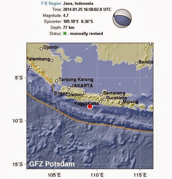
  1. The M4.7 (USGS), 4.3 (GFZ) on 2014-01-25 23:58:02 UTC+07:00 at epicenter
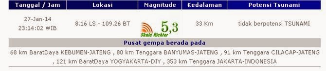
  2. The M5.3 (BMKG), 4.7 (GFZ), M5.0 (USGS) on 2014-01-27 23:14:00 UTC+07:00 at epicenter
Comparison of the latest aftershock calculated by the BMKG, GFZ and USGS:
BMKG:

GFZ: with moment tensor solution resolving a thrust fault event.


USGS:


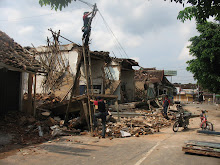
Severe damage were observed mainly in the Kebumen region, were tens of buildings were damage. No casualties were reported. Resident as far as Malang, east Java and Jakarta in the northwestern part of the island have been reported to experience strong ground shaking lasting 3-10 seconds.

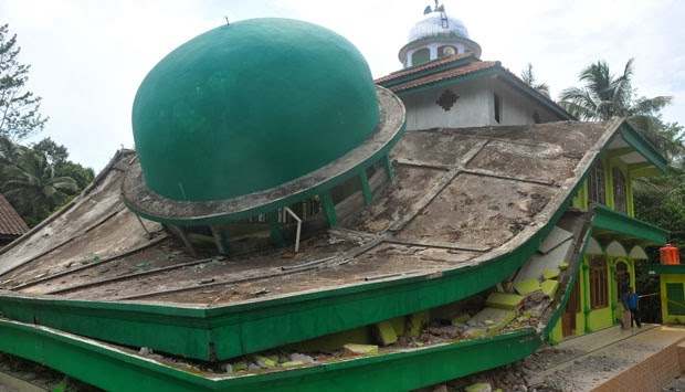
Damaged mosque at Kranggan village, Banyumas regency, Central Java (25/1), tens of houses collapses in the vicinity (image source: Tempo)

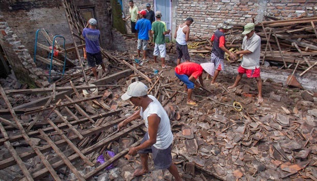
Collapsed house at Tirtohargo village, Bantul regency, Yogyakarta (25/1), five houses collapses in the vicinity (image source: Tempo)