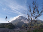
 Indonesian Geological Agency has raised the alert level for Karangateng volcano on May 31, 2009 into its maximum level. It began spewing hot clouds and lava, and volcanic tremor on May 30, 2009. Hundreds of people were evacuated from near the volcano. Total number of vulnerable population approximately 3,000 people.
Karangetang Volcano is located in central Sangihe Islands, lies at the northern end of the island of Siau, north of Sulawesi Indonesia. It is a stratovolcano rising 1784 m above sea level and 2700 m above the ocean floor. The summit contains five nested craters aligned in a north-south direction, the largest of which is 350 m in diameter. More than 40 eruptions recorded since 1675 and many additional small eruptions that were not documented in the historical record (Catalog of Active Volcanoes of the World: Neumann van Padang, 1951). The last deadly eruption of Karangetang occurred in 1992, which killed at least six villagers. Twentieth-century eruptions have included frequent explosive activity sometimes accompanied by pyroclastic flows and lahars.
(Photo caption: Karangetang volcano, 2008, Photo by Meiyer Damima)
Location of Karangetang volcano at Sangihe islands, north of Sulawesi main island
(in repair)
(in repair)
Zoom in satellite image of Karangetang volcano at Siau island
(in repair)
(in repair)


0 comments:
Post a Comment