Friday, February 3, 2012

Indonesian government raises alert on Semeru Mount in East Java

The Indonesian Volcanology Center has raised the alert from level II to Level III on Semeru Mt in Lumajang, East Java on Friday, February 3rd, 2012 following increase of lava flow and pyroclastic flow observed over the past two days. According to information released by the center, pyroclastic flow observed 00.34 local time on Thursday which extends to the area 300 meters from the Jongring Seloko crater, SE of the volcano. It was followed by another pyroclastic flow at 07.47 on Thursday reached 2.5 km from the crater, lava flow also observed near the crater rim area and reach as far as 750 meters from the crater rim. A 4 km exclusion zone has been placed on the SE slopes of the volcano where pyroclastic flows occur. Climbers are advised to remain at least 1 km from Jonggring Seloko crater.

As for info, the Center has set four levels increasing intensity of volcanic activity with level I for the lowest and level IV for the highest.

The 3,676-metre (12,060-ft) Semeru is one of the most active volcanoes on Java Island. Geographically, it’s located at the position of 8° 06’ 30’’ Latitude and 112° 55’ Longitude. Its highest point is called Mahameru (+ 3676 meter) which is the highest peak on Java. The last eruptions phase activity were observed at the volcano on 9,14, and 17 June 2011. Activity resumed at the end of December 2011. Between 29th December 2011 and 15th January 2012 there were eight explosions at Jonggring Seloko crater, sending ash up to 600 m high. The nearest major city to Semeru is Surabaya. The area is also popular with hikers and nearby Mount Bromo is a well known tourist site.

Hot-line Information: Geological Hazard andVolcanology center of Indonesia (Pusat Vulkanologi dan Mitigasi Bencana Geologi) phone number: +62-22-7272606

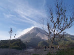
Figure caption: Semeru mountain (the tallest volcano on the background) during its quiescence period with the Bromo-Tengger caldera at the foreground, at Bromo-Tengger-Semeru National Park. (Photo courtesy of: Gayatri Indah Marliyani, captured at 5.42AM, January 8, 2006)

Tuesday, January 10, 2012

Magnitude 7.3 Aceh Earthquake, January 11, 2012

A magnitude-7.3 earthquake struck the western shore of Indonesia's Sumatra island on Wednesday, January 11, 2012 at 12:37:01 AM at epicenter. The epicenter located offshore at 2.396°N, 93.175°E at 29.1 km depth, 423 km (262 miles) SW of Banda Aceh, Sumatra, Indonesia. Tsunami warning being issued for coastline area of Aceh, North Sumatra, Lampung and Bengkulu forced resident lives along the shoreline to be evacuated to higher ground.

Update: Tsunami warning was lifted two hours after the earthquake. No damage and causalities being reported yet.


Image source: USGS

Wednesday, November 30, 2011

Nias Landslide, Wednesday, November 30, 2011

Seven people were killed and 30 others were missing after heavy rain triggered a landslide on the Indonesian island of Nias on Wednesday, 30 November 2011. The landslide slammed into a village in Majo Kampung Barije district on the island in North Sumatra province. At least 37 houses were buried under the mud, seven people were confirmed dead and thirty other people were missing.

It is known that the prominent factors of landslide in Indonesia are lithology and morphology. Highly weathered material can be easily found in Indonesia. If it occurred on the steep morphology and water penetrate into the material, it will weaken the slope and increase the potential of mass movement as it cross the threshold. Heavy rains were recorded over the past three days prior to the landslide.

Evacuation still in progress, although it has been limited by the weather condition.

Monday, October 3, 2011

Indonesian government raises alert on Anak Krakatau volcano in Sunda Strait, West Java

The Indonesian Volcanology Center has raised the alert from level II to Level III on Anak Krakatau Mt in Sunda Srait since last Sunday of September 30, 2011 following a number of volcanic quakes and increase of solfatara zone in the mountain flank. As for info, the Center has set four levels increasing intensity of volcanic activity with level I for the lowest and level IV for the highest.

Anak Krakatau Mt is one of the most active volcanoes in Indonesia, located within the area of the older Krakatau complex now represent as Panjang, Sertang and Rakata islands. Geographically, it’s located at the position of -6.100615,105.422688. The closest cities are Lampung, Jakarta and Banten. One hundred eruptions were recorded since June 11, 1927 with recurrence intervals every 1-6 years. Since 2007, eruptions phase occur every year in this mountain. Unfortunately, seismograph and several GPS station in Anak Krakatau were buried by eruption material lately, resulting lack of observation since July 10, 2011. On September 18, 2011 the seismograph back to its normal operation and the center observe rising in activity including the occurrence of volcanic swarm with intensity of 1-4 events per minutes.

For the last four years, strombolian eruption predominate the eruption type of this volcano. The explosive eruption disperses materials in bomb, blocks, lapilli and ash size that spread in a radius of 500-1500 around the volcano.

The Center said that at the moment it was not necessary to evacuate residents on the coast line area near the Sunda Strait but asked the residents as well as tourists to keep away from the mountain. The Anak Krakatau crater area and the area within 2km from the volcano is closed to any activity.

Hot-line Information: Geological Hazard andVolcanology center of Indonesia (Pusat Vulkanologi dan Mitigasi Bencana Geologi) phone number: +62-22-7272606 and Krakatau Observatory Center: +62-254-651449.

Location map of the Anak Krakatau Mt.

Upper Figure caption: Anak Krakatau Mt. (image source: Kompas)

Monday, September 5, 2011

M 6.7 North Sumatra Earthquake, Tuesday, September 6, 2011

Magnitude 6.7 struck North Sumatra region on Tuesday, September 06, 2011 at 00:55 AM local time. The epicenter located 59 km northeast of Singkilbaru-Aceh, 75 km southeast of Kutacane-Aceh, 78 km southwest of Kabanjahe-North Sumatra, 100 km southwest of Medan, onshore at position 2.81°S, 97.85°E with a depth of 78 km.

As in Tuesday September 6, 2011, 3.15 AM, no fatalities reported yet. Power is out throughout the epicenter region. Even though the authorities ensure that no tsunami is going to occurs, panicked residents still fled to higher ground fearing giant waves.

Update: As in September 9, 2011, at least two fatalities were reported and numbers of building collapses.

Figure: BMKG (Indonesian climatology and geophysics agency) shake map of this earthquake (Source)

Resident inspecting the damaged house caused by the earthquake (image source)

Sunday, August 28, 2011

Lokon’s Mountain, North Sulawesi erupts again, August 28, 2011

The eruption of Mount Lokon has not abated. On Sunday, August 28, 2011 at 07.51 local time, another eruption occurred again following last month eruption. According to The Volcanic and Geological Disaster Mitigation Center (PVMBG) of Indonesia, the eruptions column reached 2,500 meters from Topaluan crater of the mountain. Series of volcanic tremors were recorded since 8pm on Saturday. With an extensive increasing numbers of earthquakes occurs about six hours prior to the eruption, 69 volcanic tremors were recorded during span time of 00.00-06.00 that day. Previously, after the July 14 eruption, the agency has lowered this mount's alert level from level IV to level III.


Images source: Detik